




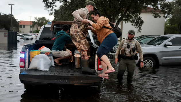
Parts of Florida have seen more than a foot of rain over the past two days, with additional heavy rainfall expected Thursday and Friday as flooding has cut off some neighborhoods and sent water into homes.
Plantation, Florida, has recorded 16.4 inches of rain, while Hollywood has seen 13.8 inches and Fort Lauderdale has received 12.2 inches.
The St. Johns River near Cocoa has risen above record levels, reaching 17.8 feet. Neighborhoods in Cocoa and Rockledge have been cut off by feet of standing water, with vehicles abandoned and water entering homes.
Additional rounds of heavy rain are expected Thursday and Friday, including a Level 2 out of 4 flood threat in place Thursday from Miami to Jacksonville. On Friday, that threat shifts slightly north, covering the area from West Palm Beach to Jacksonville.
A Level 3 out of 4 flood threat is in place over Florida's Space Coast both days. On Thursday, it extends from Port St. Lucie to Daytona Beach, while Friday's threat covers the area from Palm Bay to Orlando.
In areas where heavy rain persists for hours, rainfall totals could reach 6 to 12 inches and, on Saturday, the system responsible for the flooding in Florida is expected to begin moving north as a more organized low-pressure system takes shape off the coast.
A Level 2 out of 4 flood threat is forecast from Daytona Beach to Charleston on Saturday, where rounds of rain could become heavy at times.
The storm system could also take on tropical characteristics as it moves up the coast, with the National Hurricane Center giving it a 60% chance of developing into a tropical or subtropical system this weekend.
If it becomes a named tropical storm, the next name on the list would be Kyle.
Regardless of whether it receives a name, the system is expected to have nor'easter characteristics and bring strong winds to the coastline this weekend. Impacts could include localized major beach erosion, minor to moderate coastal flooding and rainfall that could cause urban flash flooding at times.
The exact track remains uncertain because the system has not yet developed. Its path will depend in part on how it interacts with frontal boundaries in the region.
On Sunday, North Carolina and Virginia could see heavy rain, strong winds, coastal flooding and beach erosion.
By Monday morning, rain could reach the New England coast before moving out during the afternoon.
Copyright © 2026, ABC Audio. All rights reserved.